Camino del Norte · Stage 1
Irún to San Sebastián
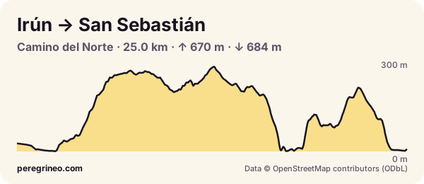
Irún to San Sebastián on the Camino del Norte: 25.0 km, 670 m up and 684 m down. Elevation profile, villages, albergues, water and tips.
- kilometres
- 25.0
- ascent
- 670 m
- descent
- 684 m
- highest point
- 293 m
- lowest point
- 1 m
- difficulty
- hard
Surface: 42 % asphalt, 42 % track and 16 % footpath.
The Norte starts hard: from Irún you climb Mount Jaizkibel, with the Bay of Biscay on one side, and drop to Pasaia, where a small launch crosses the harbour mouth. Then another climb over Mount Ulia and the descent to San Sebastián with La Concha bay in front of you. A first day with a lot of climbing.
Villages and services on this stage
The villages the stage passes through, with the distance from the start and what each one has. Services change: check them on the day.
| Km | Village | Albergues | Services |
|---|---|---|---|
| 0.0 | Irun | 4 | bar · shop · pharmacy · ATM · fountain |
| 25.0 | Donostia / San Sebastián | 35 | bar · shop · pharmacy · ATM · fountain |
PeregriNeo data based on © OpenStreetMap contributors (ODbL) and Copernicus DEM GLO-30 elevations (© DLR e.V. 2010-2014 and © Airbus Defence and Space GmbH 2014-2018, EU and ESA).
Put this profile on your website
Copy this code into your blog or your albergue’s website: it shows the stage profile and links here.
FAQ
How far is it from Irún to San Sebastián?
About 25.0 km along the Camino, with 670 m of total ascent and 684 m of descent, by our measurements.
How long does the Irún to San Sebastián stage take?
At an easy pilgrim pace, between 6.5 and 8.5 hours of walking, not counting stops. Hills count: every 100 m of climbing adds about 10 minutes.
Where to sleep in San Sebastián?
There are 35 albergues in San Sebastián, plus other places to stay. Book ahead in high season.