Portuguese Coastal Camino · Stage 6
Oia to Baiona
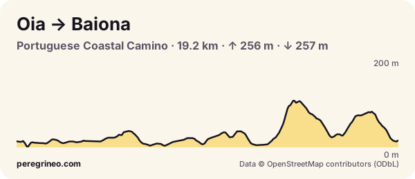
Oia to Baiona on the Portuguese Coastal Camino: 19.2 km, 256 m up and 257 m down. Elevation profile, villages, albergues, water and tips.
- kilometres
- 19.2
- ascent
- 256 m
- descent
- 257 m
- highest point
- 109 m
- lowest point
- 4 m
- difficulty
- moderate
Surface: 71 % asphalt, 24 % track and 5 % footpath.
A beautiful stretch beside the ocean, with Cape Silleiro and the way into Baiona, a fishing town with its Monterreal fortress. In 1493 the caravel Pinta landed in Baiona with the news of the discovery of America.
Villages and services on this stage
The villages the stage passes through, with the distance from the start and what each one has. Services change: check them on the day.
| Km | Village | Albergues | Services |
|---|---|---|---|
| 0.1 | Redondeliño | — | bar |
| 0.3 | O Arrabal | — | bar · shop · pharmacy |
| 3.3 | A Volta das Orelludas | — | bar |
| 4.0 | O Anguido | 2 | bar |
| 4.3 | Os Loureiros | 1 | bar |
| 4.8 | Portosanín | — | shop |
| 6.8 | O Porto | 1 | bar · fountain |
| 8.5 | Pedra Rubia | — | shop |
| 11.5 | A Ermida | — | bar |
| 15.1 | O Cabreiro | — | bar · fountain |
| 15.7 | Carballo | — | bar · fountain |
| 15.9 | A Ponte | — | bar |
| 18.1 | Santo Antón | — | bar · fountain |
| 18.6 | Cova Terreña | 1 | bar · shop · fountain |
| 19.2 | Baiona | 2 | bar · shop · pharmacy · fountain |
PeregriNeo data based on © OpenStreetMap contributors (ODbL) and Copernicus DEM GLO-30 elevations (© DLR e.V. 2010-2014 and © Airbus Defence and Space GmbH 2014-2018, EU and ESA).
Put this profile on your website
Copy this code into your blog or your albergue’s website: it shows the stage profile and links here.
FAQ
How far is it from Oia to Baiona?
About 19.2 km along the Camino, with 256 m of total ascent and 257 m of descent, by our measurements.
How long does the Oia to Baiona stage take?
At an easy pilgrim pace, between 4.5 and 6.0 hours of walking, not counting stops. Hills count: every 100 m of climbing adds about 10 minutes.
Where to sleep in Baiona?
There are 2 albergues in Baiona, plus other places to stay. Book ahead in high season.